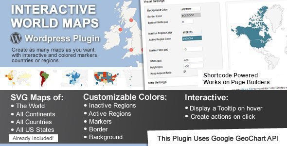
Interactive World Maps Plugin
Interactive World Maps is a WordPress plugin to create as many maps as you want, with interactive and colored markers, continents, countries or regions.
✨ Key Features:
-
🖱️ Fully Interactive Regions
Click, hover, and zoom into countries, states, or custom regions. Each area can have a unique tooltip, link, or information popup. -
📍 Custom Markers & Pins
Place unlimited markers anywhere on the map. Choose from various icons or upload your own to highlight specific locations like offices, events, or points of interest. -
🎨 Visual Customization
Easily change colors for regions, markers, water, and borders to match your website’s branding. Control hover effects, popup styles, and more from a user-friendly interface. -
📊 Data Visualization
Create choropleth maps by assigning different colors to regions based on your data (e.g., sales by country, population density). Perfect for displaying statistics in an engaging way. -
🌐 Multi-Map Support
Create and manage multiple different maps for various purposes (e.g., a store locator map, a global team map, a project distribution map) all from one dashboard. -
🚀 Fast & SEO Friendly
Built with clean code for optimal performance. Map data is rendered efficiently to ensure it doesn’t slow down your site and is structured to be crawlable by search engines.
Why Choose This Plugin?
This plugin is the perfect blend of power and simplicity. It empowers marketers, bloggers, and business owners to create professional, data-rich interactive maps without hiring a developer. Elevate your content, improve user engagement, and present your global data in the most visually appealing way possible.
Tags: interactive map, world map, vector map, location finder, data visualization, custom markers, choropleth, responsive, shortcode, business locations